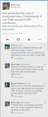
 April 30, 2013 10:51 am: Burt sent a tweet about the new dataset and noted there were no GPS coordinates, only TMK values. TMK (Tax Map Key) numbers are used as parcel identifiers in Hawaii, so the dataset showed which parcels the trees were on, but not the specfic location of each tree.
Ryan Ozawa (@hawaii) brought me (@rajhawaii) into the conversation suggesting I might have an app for TMKs. I didn't, but it got me thinking that I could build one pretty easily.
I started by exporting the dataset as a spreadsheet and then bringing it into ArcGIS for Desktop. I've been using this GIS (geographic information system) software for many years and it is great for exploring and editing map data, combining different map datasets, and doing spatial analysis. I knew that the City's mapping open data portal (http://cchnl.maps.arcgis.com) had TMK parcels as a map service. All I needed to do was to re-format the TMKs in the spreadsheet to match the format of the map service and then I would have a map of the parcels with exceptional trees.
Once I had the map dataset of parcels with exceptional trees, I turned to ArcGIS Online to move the data from my desktop to the City's mapping open data portal. I uploaded the dataset and published it out as a feature service. This feature service is now available for anyone to use for their own maps or mapping applications. Click here to learn more about this feature service.
Now that I had the feature service published, I needed to combine it with a basemap and define the symbology and configure the popup window to show attribute data. I again used ArcGIS Online, this time to create a web map. I choose an imagery basemap, and since this is tree data, I symbolized the parcels with a green outline and an interior green color at 90% transparency. I configured the popup window to show the common name and species name of the trees as well as some locational information. This web map is now available for anyone to use for their own mapping applications. Click here to learn more about this web map.
Now that I had a web map, I could use it conjunction with one or more map application templates to create a web map application. I started with a simple template that provides the user with a few simple tools to search for places, to change the basemap, and to share a map via email, Facebook or Twitter.
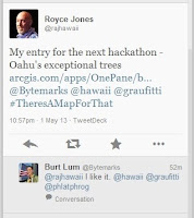
 May 1, 2013 10:57 pm: Almost exactly 36 hours after Burt's initial tweet, I was able to tweet the link to my completed web map application. Click here to see it.
I have since used the same web map to create a second application that provides the ability to search by tree name. Click here to see it.
And finally, I can embed my web map into any web page including my blog, so here it is... zoom in, zoom out, pan across to see other parts of the island. And be sure to click on a green parcel to get info on the trees!
A hui ho!
Hi Royce. What map application templates do you use to make the apps?
ReplyDeleteI used the "Basic Viewer" template for the "Exceptional Trees of Oahu" app with the text in the left column. I used the "Parcel Viewer" template for the "Exceptional Trees Finder" app and configured it so you can search for specific trees. Both templates are standard ArcGIS Online templates.
Delete