
TABLES AND TABLE RELATES
Maps are great, but what really makes our GIS (Geographic Information System) maps powerful is the data behind the map. Every feature on the map has data (attributes) that describe that feature. This data is stored in a geographic table with columns for the location/attributes and with a row for every feature. The power of the GIS is expanded even more when we relate a geographic table to other non-geographic tables. For example, a geographic table of tax map properties (parcels) might be related to a non-geographic table that lists the owner or owners of each parcel.

EDITING USING TEMPLATES

LOCAL GOVERNMENT MAPS AND APPS
For my editing example, I used a public safety data schema from the Local Government Information Model, or LGIM. Esri has developed this model based on its experience working with many state and local government agencies. Agencies who adopted the LGIM can then use free maps and map applications (apps) to quickly create new, powerful mapping applications to server their local businesses and residents. At the user group meeting I showed a few of these maps and apps.
Click here to see maps and apps for Land Records.
Click here to see maps and apps for Public Safety.
Click here to see maps and apps for Water Utilities.
Click here for more information on Local Government Maps and Apps.
And for those you who are developers, the code is available on GitHub.
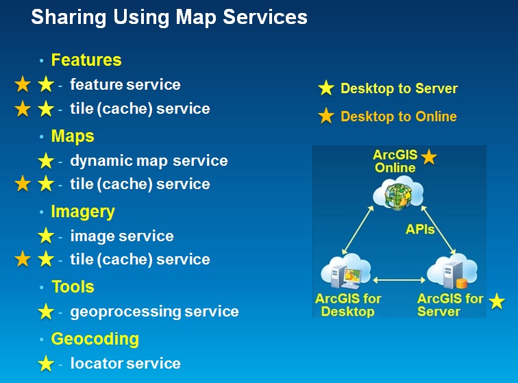
SHARING USING MAP SERVICES
 When GIS professionals share data they often use packages which work well for sharing with other GIS professionals, but require special software to use. Now we can share data using map services which can then be used in a variety of ways by both GIS professionals and those without GIS experience. During the user group meeting I briefly talked about the different types of services that you can publish from ArcGIS for Desktop 10.1 to either ArcGIS for Server or to ArcGIS Online.
In this diagram you can see which types of services you can use to share different types of data and tools. All eight types can be published to ArcGIS for Server. Four of the eight can be published to ArcGIS Online. During the meeting I published my event planning data as a feature service to ArcGIS Online. There are other types of services you can publish, click here for a complete list.
WHAT'S NEW IN ARCGIS ONLINE
The best way to keep up with what's new in ArcGIS Online is via the blogs. Here are a few links you'll find helpful:
What's New - The Latest
What's New in March 2013
Bern Szukalski's Blog (my favorite)
All ArcGIS Online Blogs
Next Maui User Group meeting is August 26th. Maybe I'll see you there!
Answers to Safe Relationships handout:
1) 1-1 (one to one)
2) F (Fee)
3) m-1 (many to one)
4) Join Tenure to Parcels using TMK, then Join "Tenure Type" to Parcels using Tenure/Tentype
5) 1-m (one to many)
6) You can, but don't! Use Relate instead.
7) Parcel 7, $200,000
8) Parcel 6, $300,000
9) Summarize Buildings table by TMK and Sum BLDGVAL, then Join the summary output table to Parcels using TMK
10) m-m (many to many)
11) Summarize Owners table by TMK and First OWNER, for all rows in summary output table where Count=1 you know the owner, for all rows where Count>1, set the owner name to "multiple" or something to indicate more than one owner. You might even include the count itself, eg: if Count=7, set owner name to "multiple (7)".
No comments:
Post a Comment